
How To Make Awesome Maps with DEM and GEO2 (Image Heavy)
-
Zeno
- Posts: 3430
- Joined: 2008-09-07 14:16
Re: [Tutorial] How to make awsome maps with DEM and GEO2 [IMG HEAVY!]]
depends on the terrain, i often zoom a bit in google, then zoom in microdem and continue until they match at the same spot
[R-DEV]Ninja2dan: Not having a spotter is like masturbating with a cheese grater...mildly amusing at first, but generally painful and bloody in the end.
Thornehaw: If all this have been evidently true, Battlefield is a much scarier and dirtier than ever imagined. Not a conspiracy, but a possibility. If it is true, then trusting another is quite worrisome.
Thornehaw: If all this have been evidently true, Battlefield is a much scarier and dirtier than ever imagined. Not a conspiracy, but a possibility. If it is true, then trusting another is quite worrisome.
-
Vicious302
- Posts: 407
- Joined: 2010-07-28 19:54
Re: [Tutorial] How to make awsome maps with DEM and GEO2 [IMG HEAVY!]]
Can anyone provide an updated tutorial on how to get this working for 64-bit I'm working on it, but fuck I think whoever is in charge of the organization of MicroDems website is on acid or something.
Last edited by Vicious302 on 2012-11-03 07:57, edited 3 times in total.
-
Rabbit
- Posts: 7818
- Joined: 2006-12-17 15:14
Re: [Tutorial] How to make awsome maps with DEM and GEO2 [IMG HEAVY!]]
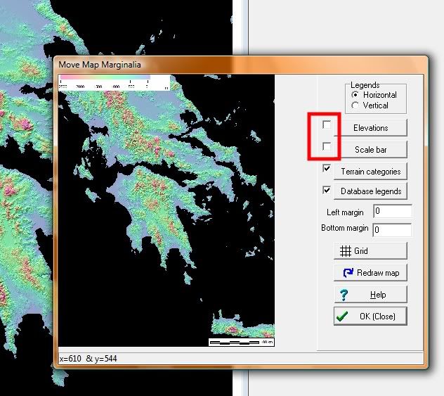
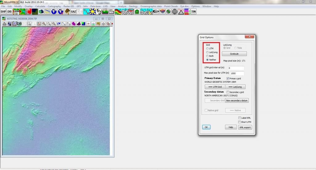
Is it normal for the grey scale to have a grid on it? It's all on the same layer so im worried the bf2 editor will see them as terrain features or not.

AfSoccer "I just don't see the natural talent."

-
VapoMan
- Retired PR Developer
- Posts: 1139
- Joined: 2009-05-29 07:11
Re: [Tutorial] How to make awsome maps with DEM and GEO2 [IMG HEAVY!]]
A grid on the actual heightmap? No there shouldn't be anything like that on there as it will be picked up in the editor and will produce some strange terrain.
 "Eight glorious sides and eight stunning angles!"
-
Zeno
- Posts: 3430
- Joined: 2008-09-07 14:16
Re: [Tutorial] How to make awsome maps with DEM and GEO2 [IMG HEAVY!]]
you need to remove the grid in MicroDem or else you end up with bottomless ravines all over your map.gx wrote:Is it normal for the grey scale to have a grid on it? It's all on the same layer so im worried the bf2 editor will see them as terrain features or not.
give me 3 sec and ill find the setting
go to the GRID settings
Last edited by Zeno on 2012-11-17 11:37, edited 1 time in total.
[R-DEV]Ninja2dan: Not having a spotter is like masturbating with a cheese grater...mildly amusing at first, but generally painful and bloody in the end.
Thornehaw: If all this have been evidently true, Battlefield is a much scarier and dirtier than ever imagined. Not a conspiracy, but a possibility. If it is true, then trusting another is quite worrisome.
Thornehaw: If all this have been evidently true, Battlefield is a much scarier and dirtier than ever imagined. Not a conspiracy, but a possibility. If it is true, then trusting another is quite worrisome.
-
Rabbit
- Posts: 7818
- Joined: 2006-12-17 15:14
Re: [Tutorial] How to make awsome maps with DEM and GEO2 [IMG HEAVY!]]
I un checked both of those, but for some reason that grid appears yet when I went bak to see if the grip re applied itself there it had not, I don't know what's causing it.Zeno wrote:you need to remove the grid in MicroDem or else you end up with bottomless ravines all over your map.
give me 3 sec and ill find the setting
go to the GRID settings
AfSoccer "I just don't see the natural talent."
-
Durkie
- Posts: 264
- Joined: 2009-01-12 08:10
Re: [Tutorial] How to make awsome maps with DEM and GEO2 [IMG HEAVY!]]
Go to the grid setting and set it to Neither.
You can get there by right clicking and then Grid/graticule
You can get there by right clicking and then Grid/graticule
Last edited by Durkie on 2012-11-17 18:59, edited 1 time in total.
"Goddam it, you'll never get the Purple Heart hiding in a foxhole! Follow me!"
Captain Henry P. Jim Crowe
Captain Henry P. Jim Crowe
-
Rabbit
- Posts: 7818
- Joined: 2006-12-17 15:14
Re: [Tutorial] How to make awsome maps with DEM and GEO2 [IMG HEAVY!]]
Thanks that did it. Next question, I've been reading the tut on adding a fitting area to your surrounding terrain, and I want it all to fit into that whole area and not just the main portion of the level, so is there anything special I have to do in photoshop in the next step with the grey scale? I want to main area of the level to be 1024 scale 1 so does that mean for the grey scale step I have to set it to 4096x4096?Durkie wrote:Go to the grid setting and set it to Neither.
You can get there by right clicking and then Grid/graticule
AfSoccer "I just don't see the natural talent."
-
Durkie
- Posts: 264
- Joined: 2009-01-12 08:10
Re: [Tutorial] How to make awsome maps with DEM and GEO2 [IMG HEAVY!]]
I would advise you to follow this tutorial by mineral for the photoshop part: https://docs.google.com/document/pub?id ... -FgCoQXIv0
or this tutorial to use geocontrol and BF2HMT:https://www.realitymod.com/forum/f189-m ... f2hmt.html
or this tutorial to use geocontrol and BF2HMT:https://www.realitymod.com/forum/f189-m ... f2hmt.html
"Goddam it, you'll never get the Purple Heart hiding in a foxhole! Follow me!"
Captain Henry P. Jim Crowe
Captain Henry P. Jim Crowe
-
Rabbit
- Posts: 7818
- Joined: 2006-12-17 15:14
Re: [Tutorial] How to make awsome maps with DEM and GEO2 [IMG HEAVY!]]
Damn, seems my student version of photoshop can't do this process, I get stuck at the checking grey scale and 8 bit. I can only check 16
AfSoccer "I just don't see the natural talent."
-
Durkie
- Posts: 264
- Joined: 2009-01-12 08:10
Re: [Tutorial] How to make awsome maps with DEM and GEO2 [IMG HEAVY!]]
If you want you can upload the file and I can change it for you
"Goddam it, you'll never get the Purple Heart hiding in a foxhole! Follow me!"
Captain Henry P. Jim Crowe
Captain Henry P. Jim Crowe
-
Hawkowl
- Posts: 7
- Joined: 2013-01-30 00:24
Re: [Tutorial] How to make awsome maps with DEM and GEO2 [IMG HEAVY!]]
It may be a stupid question, But can I use L3DT as the terrain editor for the microdem file? asnd is the photoshop step necesary? I have gimp and L3DT standard because they're free and they are easy to use. I guess the ultimate question is: can I substitute programs here for programs I have? or do I have to use the ones here?
-
Durkie
- Posts: 264
- Joined: 2009-01-12 08:10
Re: [Tutorial] How to make awsome maps with DEM and GEO2 [IMG HEAVY!]]
When the import and export options are the same I can't see a problem with it but I don't have experience with gimp our L3DT.
"Goddam it, you'll never get the Purple Heart hiding in a foxhole! Follow me!"
Captain Henry P. Jim Crowe
Captain Henry P. Jim Crowe
-
Mineral

- Retired PR Developer
- Posts: 8533
- Joined: 2012-01-02 12:37
- Location: Belgium
Re: [Tutorial] How to make awsome maps with DEM and GEO2 [IMG HEAVY!]]
l3DT free has a max export size of 1024x1024 no? Has been a while since I opened it so I could be mistaken. The 90trail had a bigger size tho. But yeah, if you can use the same functions and saving as photoshop, then I don't see why not 

-
Hawkowl
- Posts: 7
- Joined: 2013-01-30 00:24
Re: [Tutorial] How to make awsome maps with DEM and GEO2 [IMG HEAVY!]]
From what I have done recently it's 2048x2048 but I may be remembering incorrectly. Thanks for answering
-
Rabbit
- Posts: 7818
- Joined: 2006-12-17 15:14
Re: [Tutorial] How to make awsome maps with DEM and GEO2 [IMG HEAVY!]]
So for data I have been using a link AFsoccer recommended to me.
SRTM Data Search
I have found another site that seems to have pretty awesome detail.
http://dds.cr.usgs.gov/srtm/SRTM_image_ ... 01.inc.jpg
Some files here are in .hgt not sure if a plug-in is needed or what, also its not the most user friendly as it gives non specific coordinates rather than picking them from a map.
Anyway its worth looking into in my opinion.
Index of /srtm
Been looking through the info they have in version 2.
AfSoccer "I just don't see the natural talent."
-
karambaitos
- Posts: 3788
- Joined: 2008-08-02 14:14
Re: [Tutorial] How to make awsome maps with DEM and GEO2 [IMG HEAVY!]]
EarthExplorer
i found this you can choose the type of data you want to serch for in a certain block, and it searches miltiple databases, downside is you have to register in order to download the data and there are a million serious type questions, and its a bit finicky so it takes some time to figure out,
i found this you can choose the type of data you want to serch for in a certain block, and it searches miltiple databases, downside is you have to register in order to download the data and there are a million serious type questions, and its a bit finicky so it takes some time to figure out,
There is only one unforgivable lie That is the lie that says, This is the end, you are the conqueror, you have achieved it and now all that remains is to build walls higher and shelter behind them. Now, the lie says, the world is safe.? The Great Khan.
40k is deep like that.
40k is deep like that.
-
Mineral
- Retired PR Developer
- Posts: 8533
- Joined: 2012-01-02 12:37
- Location: Belgium
-
Devastator gr
- Posts: 19
- Joined: 2013-10-18 04:21
Re: How To Make Awesome Maps with DEM and GEO2 (Image Heavy)
hi! i give myself a shot at mapping. but icant even start.i start google earth with srtm 4.1 but there is no grid on the glode at all and so i cant save my working area and follow into the next steps. (elevation checked).any solution?
This is where we hold them..this is where we fight..this is where they DIE
-
Ason

- PR:BF2 Developer
- Posts: 1749
- Joined: 2012-10-22 10:29
Re: How To Make Awesome Maps with DEM and GEO2 (Image Heavy)
I'm having the same problem, I think I can get the grid but I can't save it 